8/27/2013 - CORRECTIONS: I have a number of corrections to this blog post following a conversation with a representative of Isakson Living. Note that I refer to the independent living units as a single building, because they are all contiguous, with a number of courtyards in the center. Isakson Living calls these 11 separate buildings. Anyhow, the westernmost of the north facing "buildings" "steps down" the hill from the majority of the north facing "buildings", meaning its base is at a lower elevation. Because of this, the retaining wall should not rise much above 15 ft around the overall development. I had earlier thought that there was not a western step down, and thus the wall must rise to 28 ft or so; this is incorrect. Also, I stated earlier the wall was 18 ft tall; this was due to the nearly illegible cross section drawings in the zoning application. The representative told me that the wall is in fact 15 ft.
Despite these corrections, I maintain my assertion that this will be like an enormous castle on a hill. Retaining walls 15 ft tall are proposed; these will be back-filled, and the land will then slope up to the base of the buildings. So, the buildings will start at an elevation significantly higher than the existing topography, and then rise 5 stories up. They will tower over the existing trees.
Here is a flood plain map of the site (from the FEMA web site):
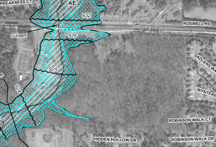
Anyone who lives near here and saw the floods in 2009 know that the flood plain map above is the real deal.
Here is a map of the proposed development from promotional materials:
Here is a map of the proposed development from promotional materials:
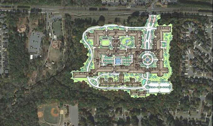
Note how the curves of the proposed development along the west side match the flood plain contours.
How does one build so close to the flood plain? Retaining walls and back-fill.
From the cross-sections on the zoning application, there is a retaining wall around a great deal of this development. The cross section that shows the elevations from the north side of Roswell Rd to the present location of Mrs. Tritt's house shows a retaining wall 15 ft tall. The house is at 960 ft elevation above sea level (the excellent Cobb County GIS maps can show topographical elevation contour lines). The land falls as you go west to 920 ft elevation at the creek. Anything below 926 ft is considered flood plain near Roswell Rd (this goes down to 923 ft downstream at the south end of the property).
The retaining walls appear to be at or very near the 930 ft contour line on the west side. The retaining wall is about 140 ft from Roswell Rd, and as mentioned above, is 15 ft tall in front of the existing house, at an elevation of about 940 ft.
The marketing materials note that the buildings are "stepped" to follow the natural contours. Most of the continuous building facing Roswell Rd appears to be at a single elevation of about 971 ft (this is 11 ft above the elevation at the current house, and about 35 ft above the east-bound lanes of Roswell Rd). A representative of Isakson Living told me that the westernmost part of the building is stepped down another level, so that the retaining wall will remain about 15 ft tall. The 971 ft elevation of most of the north facing building is the elevation of the floor of the parking garage, which then has 4 stories of residential above.
(The building on the east side is indeed stepped up, since it is on the enormous hill there. The land goes up to about 1045 ft elevation. The building is somewhat down the hill, at a present elevation of 1015 ft. That will be reduced to about 994 ft at the floor of the parking garage. The 21 ft of removed earth will presumably be used to back-fill the retaining walls on the west end of the property).
I will have another post to go more into the cross sections in the zoning application to show the height of these buildings when you add in the retaining walls and the built up elevations.
The important point here is that there are retaining walls up to 15 ft tall around about half of the property, particularly at the west end near the creek, the land then slopes up from these retaining walls, and the 5-story buildings (including parking garage) start from that point.
This will look like an enormous castle on a hill.
 RSS Feed
